I am working on the site’s layout and organization. I want it to be efficient for both you and me. The theme is new and I like it as it is how its name Minimatica implies, minimalist. I hate a cluttered page and that is where I felt my other theme was going to take the site.
I am still orienting myself to the functions of the new theme. The slider at this time is set to chronologically list my posts as I add them. I will change how that is used later, but it works for the time being. Since approximately half my family may read in Spanish I felt it was important that I create a dual language setup. I have found a nice plug-in that allows the user to select the language in which they would like to read the pages. The default is set to English as this is my preferred language to write in. The translations are done through both Goggle and Bing and it seems to do a fairly nice job of it. As no translator is perfect it is a plus that I can edit any translations I feel are inaccurate. Please bear with me as I learn to use the editing functions of the new plug-in.
I will try not to let this put a damper on additional posts. Thank you for your patience 🙂
At this moment I am sitting and enjoying watching the opening ceremonies of the 2012 Summer Olympics in London. I am normally a bigger fan of the winter Olympic games, but have found myself being an active spectator 😀 in both the 2008 Beijing and 2012 London summer games. I enjoy watching our athletes compete and commend all for their participation in the games.
I have already downloaded the official London 2012 Join In app and the Results app to keep me posted on how we are doing in the events. There was a similar app available during the 2010 winter Olympic games in Vancouver which was great as you got to not only follow the events, but the athletes tweets as well during the games. These apps are available for both Android and iOS devices and can be found here.
Finally got back from my trip to the White Mountains. What a trip that was, not ever having done that before. A real learning experience, but let me start from the beginning…
The Drive
Saturday I’m finally on the road by 4:30 am. I wanted to get rolling and on my way to the mountains right after work on Friday so I could be there by 9:00 pm and set up camp somewhere close to the parking area. This would allow me to be able to start bright and early on Saturday morning. Not so. I still had a few loose ends I had to tie up before I could leave. I packed the bag. It did not pack well and I wanted to unload it and pack it again. I was satisfied after the second attempt and figured any more adjustments it needed could be done before I started the trek.
I went to EMS that same night and picked up the bear canister I had been putting off. I also picked up a Marmot shell jacket and EMS pants. I got done repacking about 11:00 pm that night and went to bed.
The alarm at 3:00 am woke me from my sleep and I forced myself out of bed. I had a five-hour drive ahead of me. I had to get going as soon as possible as I was hoping to be at the parking area by 9:00 am. I checked and rechecked to make certain I had everything I needed. God forbid I’d be out in the middle of nowhere and not have something essential I needed in my pack.
Finally on the road to New Hampshire it started to rain. I had been checking the weather numerous times during the week for the area I was headed to. It was supposed to be clear weather for Saturday with some rain possible on Sunday. It was surprising to see rain as I made my way down the road. Mount Washington if not the White Mountains in general is known to have some of the worst weather in the world.
I took I91 N and turned off toward Lincoln, NH. From there I took the Kancamagus Highway. This is the scenic road for the White Mountains. The views were nice, but it was somewhat hazy and taking away from what the view could be. I can imagine in the fall with all the colors turning it would look astounding.
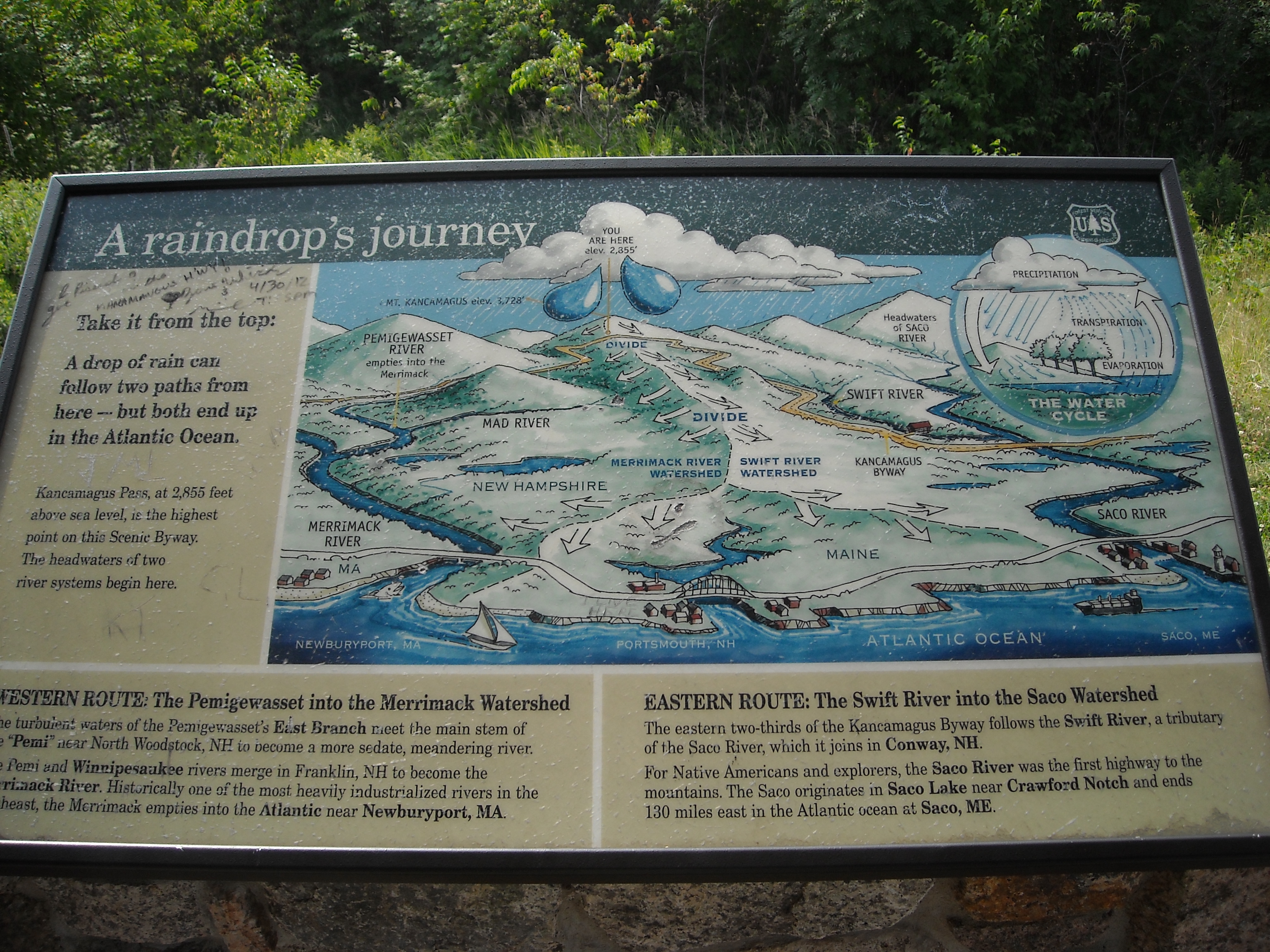
You are here
Missing my turn off for Bartlett, NH. I ended up having to drive further south and into Conway, NH. There went more of my time. Fortunately, for me though, there was an EMS in Conway. The biggest one I have seen and they had the bag I was looking for that fit the bear canister. I also found a topographical map for the High Peaks area in the Adirondacks that no store had in Hartford. Making my way north again towards Rt. 16 in Jackson I run into a traffic jam. What? Up here? I’d half expect it in New York, Boston, even Hartford, but here? Seems North Conway is a tourist town you’d best avoid if you’re only looking at going to the National Park.
The Trail
By the time I get to the Great Gulf Trail parking area it is 11:30 am. I pull in, pay my fees for parking the car and I’m on my way… or so I think I am. I failed to fill my water bottles previously. I expected that maybe there would be a spicket or someplace for that. So, I get to try the new water filter I have not even tested yet. The West Branch Peabody River follows the trail almost all the way. I fill my first bottle then dump that out and do it again, this time tasting the water. Not bad.
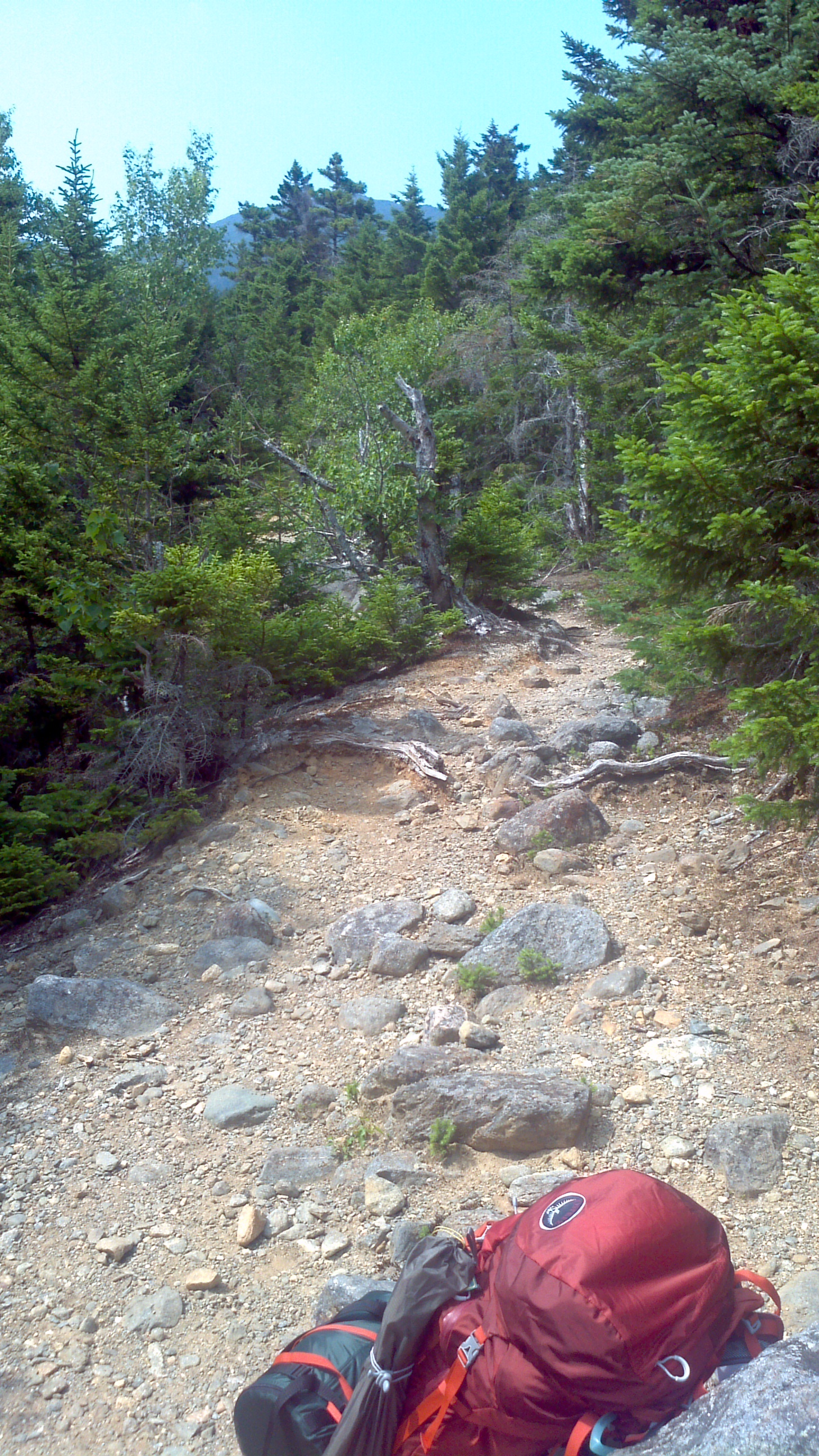
Finally on my way around 12:30 pm making my way to the Great Gulf Link Trail and then the intersection with the Osgood Trail. I will come to find out later that the Osgood Tent Platforms have been involved in a number of bear-related incidences during the last two summers. I continue on up the path further. I was already feeling my legs burn from the squats I decided to do on Sunday previous. Good thing I didn’t continue with those. I was going to need my legs. I see an opening ahead and I decide to take a break and to get a shot of where I am.
That is quite possibly Mt. Washington in the distance considering from where I took the shot. Further on down the road I come to the intersection of the Osgood Cutoff and Madison Gulf trails. Great Gulf is to the left and down a drop off. Not too bad so long as you hang on to trees or something sturdy. Once down there I lose sight of where the trail is supposed to head. I’m there for a short while. I have my map out when a trio joins me down the embankment wondering the same thing. They came from north of here on the Madison Gulf and were continuing south on it. We were looking at the maps, finally they decided it was across the creek, Parapet Brook I find out later on. I followed suit as there was nothing on this side of the brook. Success. What we were looking for was on the other side. There were just no markings across the brook to tell us that.
Crossing the brook I find the trail again. As I make my way through this section, I’m really feeling it in my legs. Little did I know of what lay ahead. What I would probably call large stones were starting to become boulders and were to become obstacles that I would have to step around or go over. I am carrying a pack on my back and climbing over these stones is like doing a stair stepper. Take a step, then up with the load. It was good to know that with every step I was making progress. What was not so nice was whenever the trail dropped back down after gaining rise. What a let down psychologically, all that work for nought. I’m going to have to make that back up. Truth is all that work was taking me closer to my goal. Even if I don’t make the summit, I would have made every effort trying. Months ago, a couple of years even, I had been thinking about coming out here and doing this and here I was doing it.
Onward and upward
I researched my ass off on what I was going to need to do this and I bought everything I felt that I needed. Water, most essential, and no guarantee of clean water out here. They make filtration systems for that. I was in no shape for this and I was losing water. …Op, I can’t use my poles here..have to climb over… In the end I used my Katadyn water filter 5 times to fill up my two 1-liter Nalgene bottles on my pack’s side. I made certain there was going to be a river along my route in case I needed to top off my supply. The boots I was wearing, Salomon, saved my left ankle a couple of times on my way back and the most comfortable boots I’ve worn. Felt like sneakers I’ve had for a year, and they weren’t even broken in. My trekking poles, Outdoor, must haves. Helped me to maintain my balance numerous times in the uneven terrain. Even going from boulder to boulder without having to come down. Going across the river four or five times, the poles could go in the water for balance while my boots stayed dry on the few stones that were showing. Always good to have two other “legs” to help out. Being Outdoor brand they cost less, but I will tell you they held up like troopers. Falling several times on them when coming back and they did not bend or break on me. My Jetboil I had gotten after reading about it on Brian’s blogand doing more research online. I also found out about Clif Shot Blocs from his blog. They look like Jello shots, every three shots are 100 calories. I will say they go down much easier than a nutribar and definitely supplied me with the energy I needed on the go while doing the trail and they replenish electrolytes. They also didn’t make me feel like I ate half a book.
I had now made it to Chandler Brook Trail and was on my way toward Wamsutta Trail and the last opportunity to turn off and head toward the Auto Road and try to get a ride back. After that point it’s go up to a ridge by way of either Great Gulf or Sphinx Trail or turn around. I chose to go on and ended up making camp just past the Wamsutta Trail way-point. It was getting late and I needed to get something warm in my belly and get some sleep to start early on Sunday. It was 6:30 pm. I had hiked for 6 hours today and with only four hours of sleep the previous night. A good nights rest could do me good. After setting up the tent, I pulled my Jetboil out, heated some water, and reconstituted some Lasagna with meat sauce. Wasn’t too bad. I cleaned up, put anything I figured would bring Ursa Major to my camp into the bear canister and wedged that between a couple of trees a ways from my tent. It was pretty quiet. Peaceful. I remember wondering if I was the only person out here in the wilderness. If a tree did fall out here in the forest, it made no sound. I slept good that night.
The Trek Back
Five o’clock the following morning I was up. I had camp packed up by 6:00 am and was on my way again. What I thought was rough the day before was easier than what I was headed into now. A few scrambles by the river here and there to make things interesting. I was using my trekking poles less on some parts as I was leaning forward to keep my center of gravity more in front of me, the direction I wanted to go. And so I would be using my hands more to help keep my balance. I push on finally arriving at the Sphinx Trail. The last turn off. No camping beyond this point. Next stop was Spaulding Lake which I was looking forward to seeing. As I made my way there I remember calculating in the back of my mind the amount of rise I had left to do in the remaining leg after the lake. That was approximately 1800 feet in about a mile. I have gone up 3000 feet in the last six miles. So I was going from approximately 500 foot rise per mile to 2000 foot rise on this last mile. I was already having doubts whether I was going to be able to do it. I figured I would continue to the lake and decide while I took a break there.
Spaulding Lake was beautiful. The treeline was just above and it was much more open, hence why no camping is allowed here. I had been seriously considering leaving my backpack here and making a run for the summit without it. Not only had I been considering the effort in trying to summit, but also the amount of time I would need to complete this. If I summit, I would not have the time to get back to my Jeep and head for home today. It was already after 8:00 am and I was predicting that the last leg was going to take me at least two hours to finish. So that would be three to four hours up and back to the lake. Between yesterday and today it took me eight hours to get to where I am right now. I imagine it will be faster getting back down. I estimate six hours. That would put me at 6:00 pm tonight. Much too long. That would make this a twelve-hour day and I still would have a five-hour drive ahead of me to get back home.
I have no problem deciding to turn back. There will be other days. Don’t get me wrong, it would have been nice to summit and I will come back to do this. Only this time I will have first hand experience of what the trails are like and how they relate to the information on the maps that I have purchased. I have the rest of the summer and maybe some of the fall to work on other peaks and trails and I will enjoy doing those.
Throughout the trek I was regretting having to come back along this trail. Now I was actually looking forward to making my way back. I figured that some of the stones I made my way over were going to be difficult getting back down off of. They really weren’t too bad, but, whereas I can’t remember having fallen on my way up here, I fell plenty of times making my way down. More so when I was closer to the lake and less so as I progressed further. I tried to stay on the small stepping-stones. None of the big ones. I realized after having a few missteps that if I wasn’t careful I wouldn’t be walking out of here on my own. Not how I would want my first trip to end. I make it back to the Jeep at 2:30 pm pushing myself on the last two miles to get there. I drive on back to town and find a pizza place along the way. A small pizza and some tea sure hit the spot. I look around at a few places, thinking of staying and resting before the ride home, but after the food stop and finally being off my feet I’m feeling I can do this. I arrive home around nine o’clock that night
I take my backpack with me to work the following morning to put it on the scale to see how much weight I had been carrying. My goal was to make it around 25 to 30 pounds. The bag weighted 37 pounds. With the two liters of water I had in my bottles, that would have made it 40 pounds. Amazing how easily the pounds add up. I had read in a review of this backpack, The Osprey Atmos 65, that there was no lumbar support. In further reading I find that the lumbar is generally the lower back. The area between the diaphragm and the pelvis. This part of the lower back bears the most body weight and is the most flexible which is why many people have lower back pain. In my case though I overloaded the backpack, should have been kept it around 25 pounds and I ended up carrying some of the load on my shoulders. As sore as I was in my shoulders, I felt nothing more of it by the time I got home Sunday night. I also thought I would barely be able to walk at work the following day, but I only felt it slightly in my legs. Pretty good for an old man, huh :).
Well, that’s it for now. It took me a while to get this entry done. I will work on trying to do entries of this size in parts ensuring a more timely post. Until next post…
I finally got the space i wanted to blog about what I’m doing in my life here for those interested. This is more for family and friends to keep them posted no matter where i may be in life. Anyone else is more than welcome here. I have a big trip planned for this weekend at the White Mountains in New Hampshire with a couple of days left to get together what i will need. More to come…


 At this moment I am sitting and enjoying watching the opening ceremonies of the 2012 Summer Olympics in London. I am normally a bigger fan of the winter Olympic games, but have found myself being an active spectator 😀 in both the 2008 Beijing and 2012 London summer games. I enjoy watching our athletes compete and commend all for their participation in the games.


You must be logged in to post a comment.